Google Maps aerial view of where Watervliet used to be
Street view of area where Watervliet used to be
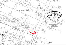
Sanborn Fire Insurance Map of Amityville from 1925 showing the location of where Freddy's used to be
Google Maps aerial view of where Freddy's used to be
Street view of the area where Freddy's used to be
Sanborn Fire Insurance Map of Amityville from 1925 showing the location of Boyd's
Google Maps aerial view of Boyd's
Street view of Boyd's
1950 Sanborn Fire Map of the area where the Gordon was presumbly located.
Streetview image of the Poughkeepsie Inn before being demolished in 2020.